[Previous Hike] [Hiking Index] [Next Hike]
[Day 2] [Day 3]
Distance: miles roundtrip
Elevation:
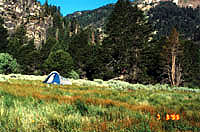
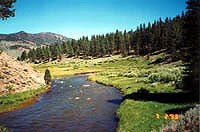
 This hike started at 6400' of elevation or so and my destination for that day
was near Carson Falls, 9+ miles away. The temperature was well into the 80s and
my pack was fairly heavy. Since this was my first solo backpacking trip, there
was no else to share the load. I also brought along a bear container since there
were supposed to be bears here. Early on the trail, I was supposed to hit a branch
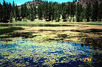
that would allow me to take the High Trail (up to 8000'), but apparently, I missed
it because I eventually encountered Wolf Lake (left) and a trail branching to
Gray's Crossing.
This hike started at 6400' of elevation or so and my destination for that day
was near Carson Falls, 9+ miles away. The temperature was well into the 80s and
my pack was fairly heavy. Since this was my first solo backpacking trip, there
was no else to share the load. I also brought along a bear container since there
were supposed to be bears here. Early on the trail, I was supposed to hit a branch
that would allow me to take the High Trail (up to 8000'), but apparently, I missed
it because I eventually encountered Wolf Lake (left) and a trail branching to
Gray's Crossing. 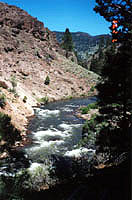
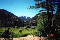
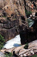
 This trail wasn't called the Carson River trail for nothing. The river looked
very appealing, but it looked fairly full from all the snow melt. According to
the map, I would have a couple river crossings to get to my destination. At about
this point, I caught up to the San Francisco couple on the trail (they would be
the only people I would see this day on the trail). As I approached them, I asked
if they were the so and so's. They were very surprised and said yes. I explained
how I knew their name and wanted to ask them about the trail and how they drove
up. They had intended to take the High Trail as well and they also missed the
branch in the trail early on. We compared notes about the trail, where we were,
and what lay ahead. With regards to the drive, they told me that I could easily
take Highway 4 back and save a couple hours driving and that the self registration
included a fire permit for the duration of your visit. It was frustrating to hear,
but it was another opportunity to achieve some inner peace.
This trail wasn't called the Carson River trail for nothing. The river looked
very appealing, but it looked fairly full from all the snow melt. According to
the map, I would have a couple river crossings to get to my destination. At about
this point, I caught up to the San Francisco couple on the trail (they would be
the only people I would see this day on the trail). As I approached them, I asked
if they were the so and so's. They were very surprised and said yes. I explained
how I knew their name and wanted to ask them about the trail and how they drove
up. They had intended to take the High Trail as well and they also missed the
branch in the trail early on. We compared notes about the trail, where we were,
and what lay ahead. With regards to the drive, they told me that I could easily
take Highway 4 back and save a couple hours driving and that the self registration
included a fire permit for the duration of your visit. It was frustrating to hear,
but it was another opportunity to achieve some inner peace. 
Distance: miles roundtrip
Elevation: